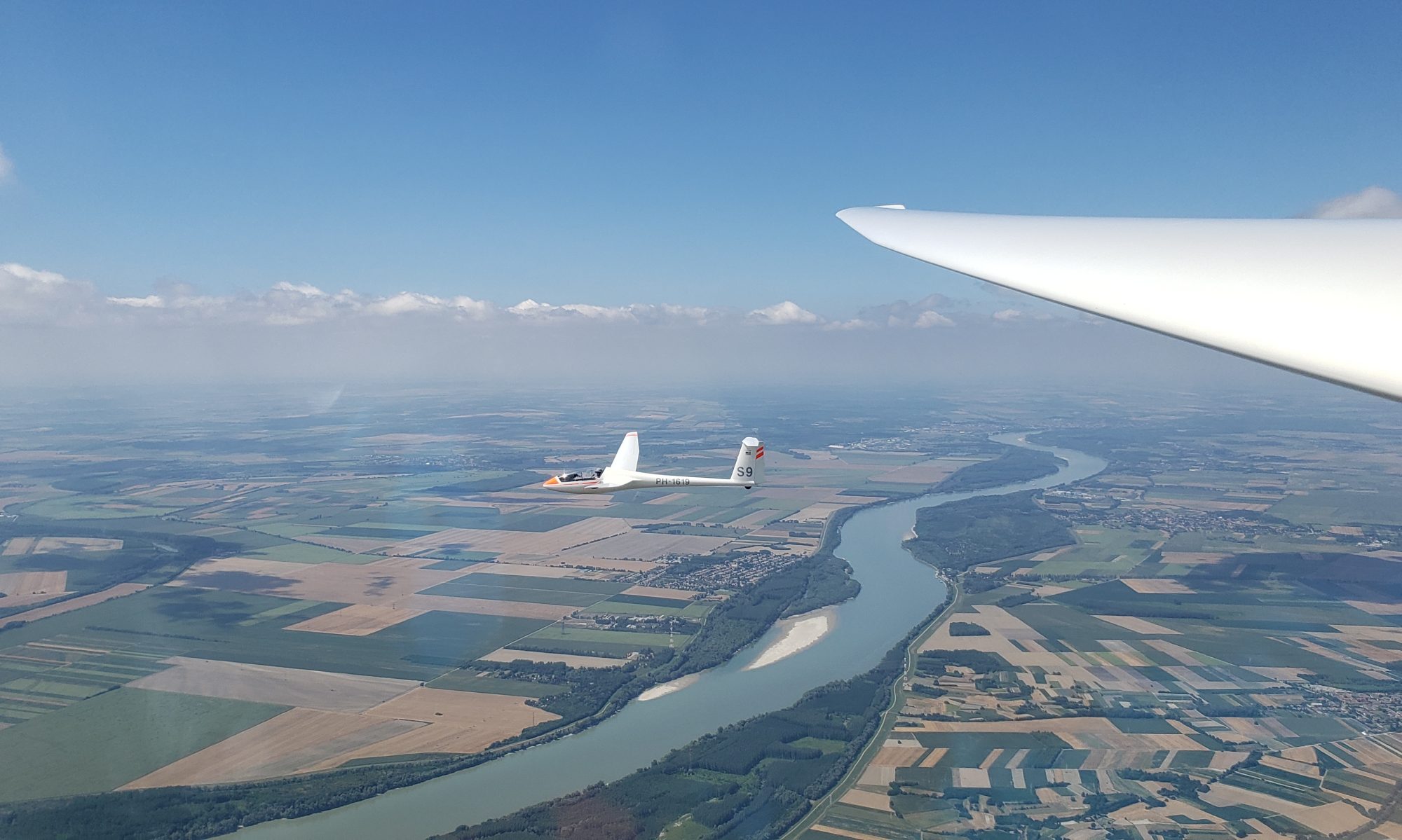

One of the most magical experiences is soaring the smooth and wonderful southeast ridge. We tend to get fewer soarable SE days and we treasure the ones that we do. Because SE days tend to be less common, our training resources are mostly geared toward the NW side. Figuring that a briefing would be useful, this overview builds on the ACA Local Ridge Training guide to provide some guidance for our beginner and intermediate pilots. First, we will discuss the weather systems that drive these days, followed by the characteristics and topography of the “local ridge”, and finally how to fly cross country to Hawk Mountain and beyond.
Key Points
- Please reference the “Blairstown SE Ridge” layer on the Ridge Map for detailed information.
- SE days usually start late in the day, with weak initial winds that get stronger toward sunset.
- Bailout altitude during ridge testing for beginners to return to Blairstown Airport:
- 2000ft MSL in a 1-26
- 1800ft MSL in high performance
- Expect tricky weather: rain, low clouds, and lower visibility. This is especially so when the winds are easterly.
- The SE side works with less wind strength and is more tolerant of off angles compared to the NW side. However, this can make the ridge lift less consistent. Certain sections may not work at all and others may be strong.
- Due to the stable conditions, ridge landouts are more likely. Expect that you can fall off the ridge at any time.
- The local ridge is from the Upper Reservoir to the Hang Glider landing zone. The section from the Delaware Water gap to the Hang glider zone is somewhat broken up and tends to be softer.
- The ridge band is usually narrower horizontally and has a stronger vertical gradient than on the NW side. (Ie: You may find the ridge is hardly working at 2000ft MSL and yet you can go 100 mph at the treetops.)
- For pilots going cross country, the area NE of the Upper Reservoir is mostly unlandable and dangerous.
- The area between the Bangor Offset and Wind Gap has no immediate fields underneath, requiring staying at or above ridge top to stay in glide of the few landing options.
- The sections near Lehigh Gap and Bake Oven Knob tend to get softer.
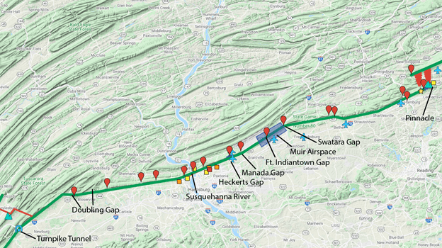
- For pilots flying southwest of Swatara Gap, contact Muir at 126.2 to cross the Class D airspace.
(Note: It is the pilot’s responsibility to study off-field landing options on The Ridge Map/Google Earth. This means reading the comments, measuring the distance of the field, assessing slope, and distance from the ridge. This briefing will guide your attention as to which fields to look at, but it is out of scope to describe the whole plan for approach and landing.)
Weather
Soarable SE days are a sharp contrast to NW days as they tend to have more stable, continental, or maritime air. Synoptically, the most common setup is a receding high-pressure system. A day or two beforehand, we usually experience a NW day as the high builds in west to east. Later, we are in the middle of the system, resulting in no wind. Finally, as the system recedes into the Atlantic, the wind picks up again, in a southeasterly direction.
Because the wind starts later in the day, the soarable “window” is often much shorter than on the NW side. Reviewing OLC traces, exceptionally few SE days result in flight durations exceeding 5.5 hours, with pilots often landing close to sunset.
The result is that a pilot launching early (often 11am-2pm) should expect a low inversion, weak winds and possibly a non-working ridge.
The more “easterly” the wind direction, the wetter the air as the air travels a shorter distance from the Atlantic. The more “southerly” it is, the drier the air.
As a result of the moisture, we generally expect few thermals, stable atmosphere, lowered visibility, and rain in the latter half of the day.
While this is a prototypical synoptic description, we will occasionally get special weather systems that alter these assumptions. However, most of the “issues” described as they relate to cloud cover, rain, and stability tend to cut across most SE days.
Soaring in Stable Conditions
Glider pilots overwhelming fly in “fair” weather, usually postfrontal systems with good thermals. SE days can strongly contrast with such weather and require an alternate mindset.
Aside from the fewer, weaker, and lower thermals, stable weather can bring rain, low visibility, fog, and lulls in the wind patterns. The adage that “you can be on the ground in two minutes at any time on a ridge” is particularly apt for the SE side.
Note that when you see any change in the airmass ahead of you, such as more cloud cover, rain, or lower visibility, this is likely to negatively affect the wind velocity. Always be prepared to land in such circumstances.
Note that most gliders lose considerable performance flying in rain.
If the temperature is cold enough, you may encounter freezing rain and experience icing conditions.
If the overcast layer is low, it can descend down to the ridge top and later even obscure the mountain. On especially moist days, expect the cloud layer to descend in the latter half of the soarable day.
As a rule, the more “easterly” the wind, the more likely you are to experience complications with wetter air.
Ridge Weather
Thanks to smoother air and a well-defined SE slope, the SE ridge needs less wind to “work” and is more tolerant of poorer wind angles than the NW side. Acceptable margins are determined by the pilot and their mentor.
- Wind Speed at Ridge Top:
- 8-10 knots (weak local ridge)
- 10-13 knots (moderate ridge: Float at 2000ft MSL @ best glide speed)
- 13 knots+ (strong ridge: Float at 2400ft)
- Wind Direction:
- Optimal ~150 degrees
- Range: 110-190 degrees
If the pilot intends to soar the ridge at the more marginal wind speeds and/or wind angles, the ridge may work better than in similar conditions on the NW side. However, the margin between “working” and “not-working” is very thin. If the wind drops a knot or two when the conditions are marginal, the ridge lift can abruptly shut off. Pilots should be cautious and prepared to land at a moment’s notice.
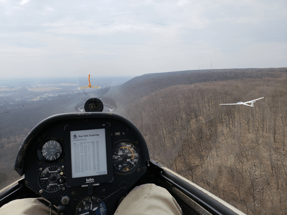
Topography

The SE ridge is much more prominent, and steeper compared to the NW ridge. The steeper angle increases the vertical component of the ridge lift, making the lift stronger, or require less wind for a comparable lift strength. However, a steeper angle also makes the lift band narrower in width. With weaker winds, the lift band is approximately two or three wingspans wide, with a very narrow sweet spot. Extra care must be taken to maintain position laterally, with most beginners struggling to do so and “hunting” back and forth in the lift.
Flying the Local SE Ridge

The local SE ridge is defined by the Upper Reservoir and the Hang glider launch site.
After tow, pilots must maintain strict gliding distance to the airport as they test the ridge. Often, this means staying within a mile of the Upper Reservoir. Once satisfied the ridge is working, the pilot may fly southwest toward the Delaware Water Gap, finding an excellently shaped mountain. The base of the ridge is heavily forested. However, the glider can maintain an adequate glideslope to the base of the valley by Rt.94, so long as the pilot stays at or above the ridge crest.
Crossing the Delaware Water Gap is usually easy, with lift often encountered in the middle. The landing options on the SW side of the Gap are Slateford Farm and the Pumphouse Fields. Both fields are marginal and require study to consider as landing options. Note that the section between the Delaware Water Gap and the hang glider field is somewhat broken up and lower than the preceding section. If the wind is marginal, you are more likely to fall off in this section. As a result, most Blairstown pilots will usually float through this section on anything other than the strongest days.
The next field is near the hang glider launch. Their landing zone is a short (~1000ft), but wide field surrounded by trees. Exercise caution in higher performing gliders as this field requires a steep approach.
Note that small weather shifts can have a large impact on the SE ridge. As a result, take care to study these landing options beforehand and always have a plan. Make sure to always maintain minimum energy (~150ft above the trees at best glide speed) if the ridge softens up. In the event the ridge is not sufficiently supporting the glider, make a decisive decision to land at a landing option. Failure to do so will expose the pilot to considerable risk.
Thermal Band
The SE ridge has a distinctly different thermal composition than the NW side as it remains in sun most of the day. As a result, powerlines, rock faces, and escarpments directly build and feed in thermals. With some experience, pilots will routinely be able to anticipate thermals in known hotspots along the ridge.
Thermal activity is often weak, and the top of the lift is usually fairly low (2400ft-4000ft MSL). Further, the thermal activity tends to be restricted mostly to the ridge.
On more southerly days, the thermals can become more turbulent and energetic. With weak winds, this can disrupt the wind flow and make the ridge band not workable. However, when the SE ridge side bakes on sunnier, southerly days, you can find closely spaced, anabatic-reinforced thermals resulting in good air 500-1500ft above the ridge.
Ridge Arrival
Returning from the SE ridge is usually not stressful compared to coming back from the NW ridge as there is little to no sink. In fact, many pilots will encounter good air over the slightly sloped terrain between the airport and the ridge. As a result, leaving at 2000ft MSL in a 1-26 and 1800ft MSL in a higher performing glider at the Upper Reservoir is adequate for a safe arrival. This approach path lines you up with the Dairy Queen field, which is an excellent alternative option.
Always be prepared to make an abbreviated pattern, normally a left-hand base-to-final on 7. Use caution entering the landing pattern as the SE wind puts the glider upwind of the airport, requiring to crab accordingly. If you are low, you may encounter sink and gusty conditions due to being in the lee of the airport hill. Finally, expect a moderate tailwind on base leg and take care to avoid button-hooking the turn.
Soaring the SE Ridge Cross Country
The SE ridge in many ways is considerably more benign than the NW side, with fewer large transitions and more landable terrain. However, it has several traps that the pilot must take care to avoid. Further, the weather is much more finicky, which increases the likelihood of falling off the ridge.
We generally advise against flying further NE of the Upper Reservoir as the landability becomes quite poor.
To fly cross country on the SE ridge, the pilot must be cross country ridge approved.
Bangor Offset

Heading SW of the hang glider zone, the pilot will encounter the Bangor Offset. This presents a formidable transition to a SGS 1-26 and requires respect even in a high-performance ship. The most notable challenges are:
- The initial ridge section SW of the offset favors an easterly wind. Use caution on more southerly days as it requires going farther to encounter the lift.
- The landability at the base of the ridge is quite poor from the Offset to Wind Gap. This requires maintaining in marginal gliding distance several landing options, noted in the figure above. The pilot must study and preselect these options before starting the transition.
Wing Gap to Hawk Mountain
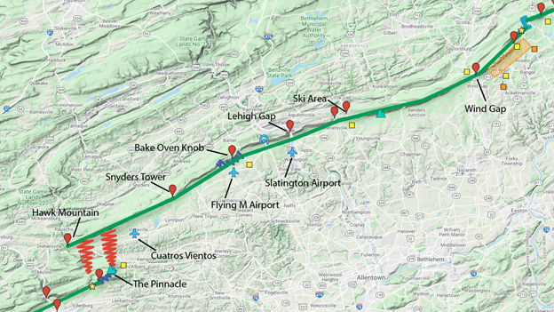
After Wind Gap, the landability is moderate and the ridge is well defined. Note that Allentown Class C airspace requires to fly under 2800ft between Wind Gap and Lehigh Gap. Caution must be exercised after the Ski Area through just beyond Lehigh Gap as this section tends to get softer. Similar caution should be exercised near Bake Oven Knob, which tends to be weaker. The ridge approaching Hawk Mountain works well, despite being behind the Pinnacle. Other than very southerly days, it is possible to fly all the way to the “wall” with solid ridge lift.
Slatington, Flying M, and Cuatros Vientos are excellent airports and serve as reliable landing options.
The Pinnacle Transition
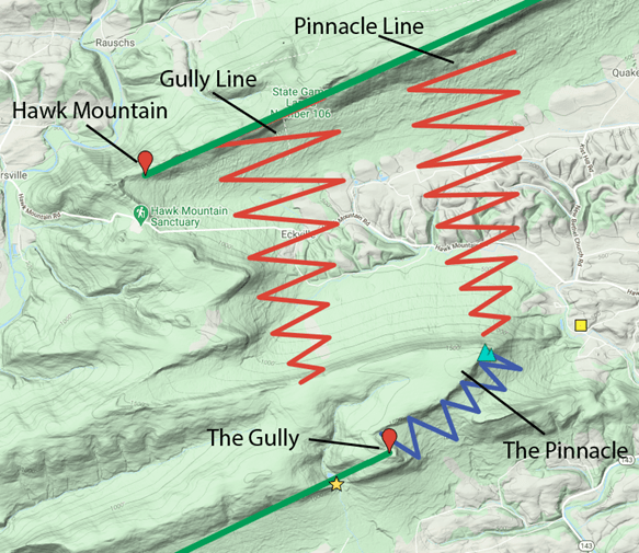
The transition beyond the Pinnacle can be quite challenging despite being only 3.5 miles in distance. Generally, more southerly days will have better thermals which makes this transition more possible. Lift lines usually set up snaking around the Pinnacle and behind a gully. Both methods are acceptable, however, crossing around the Pinnacle is safer than crossing over the top of the mountain.
In either event, be prepared for strong lee sink after committing to the transition. Mark your alternate landing option before the corner, or behind the mountain respectively. Do not commit to cross unless you are absolutely sure that you have enough energy to do so. Once you come around the corner, be prepared for the ridge not to work and land at another option further ahead.
Returning NE-bound is usually less difficult. However, occasionally the thermal activity can fall apart, causing the pilot to get stuck on the Pinnacle. This can tempt a low, downwind return back to Hawk Mountain. In this case, be prepared to land at the base of the ridge if you are coming up short.
Beyond the Pinnacle
Once the transition is complete SW bound, soaring beyond the Pinnacle is usually fairly benign. The ridge has a more rounded shape but works very well even down at ridge top. The landability is quite good in all but a couple small sections.
Approaching Swatara Gap, call Muir Tower on 126.2 to cross their airspace. Sometimes they will not let you pass if the shooting range at the base is “hot”. Muir airspace extends to Fort Indiantown Gap.
The ridge beyond Fort Indiantown Gap becomes somewhat lower and less defined, but typically still works well. Be careful at Heckert’s Gap if flying low and fast, as the ridge dips down and the lift softens up.
Approaching the Susquehanna River, the landability becomes poor. There are several landing options, although immediately by the river it is densely populated. Exercise caution crossing the river to maintain gliding distance to ridge top on the other side.
The ridge is excellent between the Susquehanna river and Doubling Gap.
Doubling Gap, while a large transition, tends to have good air through the whole area. With moderate winds, high performance gliders can sufficiently float up going in both directions that this gap does not serve as a major obstacle.
Beyond Doubling Gap, the ridge becomes prominent and excellently shaped. The ridge starts to strongly favor an easterly wind, so exercise caution on southerly days. The typical turnpoint in this region is the Turnpike Tunnel (500km out and return). Beyond the tunnel is an ammunition dump with a prohibited zone above it, which precludes the ability to continue on the windward side.
[Advanced Pilots Only!]
On the perfect day, it is possible to drop back to the Tuscarora Mountain and continue to Burnt Cabins and Dickey’s Mountain. Then, to return to Blue Mountain at Fort Loudon. Finally, approach the prohibited zone from the SW side. It is easy to get around the prohibited zone going NE bound as you would be going from a high to a low ridge and can easily skirt the perimeter of the airspace.
Soaring Northeast of the Upper Reservoir

We will periodically go to Catfish Tower, which has an occasionally landable Christmas tree farm at its base. Note that when heading SW bound again it is possible to get stuck on this ridge, unable to make the crossing back around the Upper Reservoir offset. In this case, the pilot has the option to go downwind and land in the cornfield near the former Model Airplane Field.
If heading NE of Catfish Tower and crossing the Millbrook Powerline, the ridge remains well defined all the way to the Cliffhouse. While there is no house there anymore, this knob marks the end of the commonly flown SE ridge. This area is completely unlandable.
[Advanced Pilots Only!]
Some pilots have flown farther, to Culver Lake and even High Point; however, this is highly technical soaring. The ridge requires a more easterly wind and is moderately-poorly defined in most of these sections. Further, easterly days tend to have few thermals and rain/cloud issues, which further complicate flying this section.
Useful Resources
SE Ridge Stories
- 10-13-14 SE Ridge To Susquehanna River in a 1-26
- 09-19-15 SE Ridge Day
- 05-04-17 SE Ridge to the Potomac and Return
- 10-07-17 SE Ridge Running
- 10-13-17 Bears and Bald Eagles SE Ridge
- 03-30-19 Making Miles and Positive Waves
OLC Traces
- Local Ridge/Short XC
- Cross Country
Landouts
- Chip (Local Ridge)
- Daniel (Slateford)
- Schwartz (Bangor Offset)
- Schwartz (Little Gap)
- Daniel (Bake Oven Knob)
- Schwartz (Pinnacle)
(Note: There have been many more landouts over the years. These were selected from those that were more recent and had a flight trace.)
Knowledge Quiz
- What are the geographical limits of the local ridge?
- What is the optimal wind direction for the local ridge?
- How strong does the ridge need to be for the ridge to work moderately well?
- What is the bailout altitude from the Upper Reservoir back to Blairstown Airport?
- Describe the arrival path back to the airport.
- Describe challenges you may encounter in a standard traffic pattern at Blairstown airport on a stronger wind SE day.
- Does the SE ridge usually start strong and get weaker, or start weak and get stronger?
- What kinds of things do you need to worry about on stable days?
- Name the three best landing options between the Delaware Water Gap and hang glider zone. Describe their challenges and how you would land in them.
- Why do we avoid flying NE of the Upper Reservoir?
- What are the landing options between the Upper Reservoir to Catfish Tower?
- Describe the Bangor Offset transition (both NE and SW). What are the challenges? Name the landing options, their issues and your planned approach and landing into them.
- Name the key landmarks between Wind Gap and Hawk Mountain.
- Which two areas between Wind Gap and Hawk Mountain does the ridge lift get soft?
- Name the three airports at the base of the ridge between Wind Gap and Hawk.
- What is the name of the airport that has the Class D airspace on the ridge? What is its frequency?
