
One of my ongoing efforts has been to improve safety while soaring the Appalachian Ridge system. The best tool to reference is The Ridge Map, a knowledge crowdsourcing tool. Many pilots have contributed to the landmarks/landable areas defined there and it’s a great place to start.
Blairstown Ridge Field/Landmark Slideshow
For pilots learning to fly the Blairstown ridge, I have created a slideshow of landmarks and landable areas from Millbrook to Hawk Mountain. This is a good resource to reference along with Google Earth and the Ridge Map to get a sense of what these options actually look like from a sailplane.
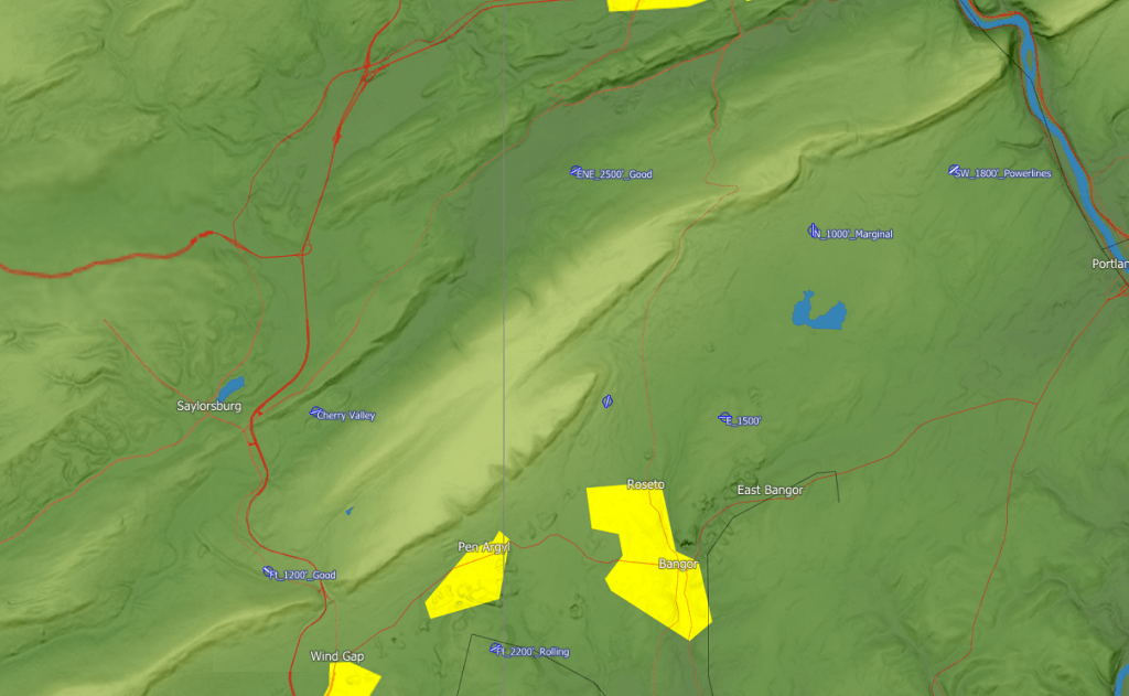
Here’s an example of a slide:

This would correspond to the following area in The Ridge Map:

Landout Database
Reviewing the Ridge Map and Google Earth, I developed a personal CUP file of 400 ridge-relevant landing options. I eliminated all non-safety related information to reduce clutter as much as possible. Each option was inspected on Google Earth for slope and obstructions. The fields were coded as grass strips so that the marker is angled in the direction of the field. The title of each field was noted by its Approach Direction, Length, and any special notes (ie: powerlines, road, etc).
If you would like this file, email me at the soaringeconomist@gmail.com. I am not listing it publicly because this tool could be misused. Ridge flying and especially ridge landouts are dangerous. This tool could be used to mitigate risk, but it requires that the pilot understand and accept several important assumptions.
Many of the options are marginal, some are even explicitly mentioned as such. The goal was to minimize and mitigate “unlandable” areas to a minimum, which means finding the first viable fields in between those areas. This means that some of the options listed are just within the margin of executing a landout in the Duckhawk in ridge conditions.
These options require considerable skill and preparation. Many fields are one-way only, and if you attempt a landing in the wrong direction you will probably break your airplane. This in its own right makes some of these options unviable when the wind direction and velocity are unfavorable.
There are some areas where there are no markers. Sometimes, this is because those regions are perfectly landable and there is no need to prepare fields in advance. In other places, this is because there is nowhere to land, and the markers are strategically placed to piece together the nearest fields. Next, this is a personal effort, so there may be omissions in tricky places, or less flown ridges, especially in the areas that are farther from my stomping grounds.
Obviously the database has nothing to say about the state of the crops in the field. This is more likely a problem in later summer/autumn soaring. During these seasons, you have to be prepared for the possibility that you might arrive and find a field full of corn! However, in many places you wouldn’t have a choice anyway as these options beat landing in the trees.
In order to use this tool correctly, you must inspect on Google Earth each landing option that you intend to put in your glide computer. This is not to say you need to look at all the 400 options from Vermont down to Virginia, just the sections you intend to fly. You cannot simply put this file into your glide computer and hit the Go-To button if you get in trouble!!! If you do so you will probably break your glider and hurt yourself!
Over the winter of ’19-’20, I spent around ~50 hours putting this together. And this is already building on many years of work already done on The Ridge Map. For ridge pilots who are already familiar with the ridge system and are planning to use this as an additional tool, budget around five hours of intensive study of the Ridge Map and the fields in this file for an intended flight route. During your study, you should pay attention to the landmarks in the Ridge Map and their notes. Note the tricky areas and thoroughly inspect the fields listed. Simulate in your mind the circumstances that may lead to a landout. Consider whether the option I listed is within your skills and margins, and whether there are alternatives that you may be more comfortable with.
If you prepare correctly, this tool could improve your situational awareness and your safety while ridge soaring. I intend to use this as an overlay of a second file, which would contain any turnpoints I would define for the day.
